Kentuckians Weathering the Storms, Once Again
Posted on May 12, 2025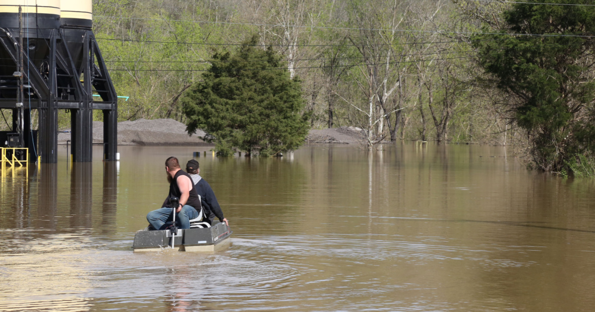
Tornadic activity and historic flooding have plagued the commonwealth this year.
To say it has been a tough weather year so far in Kentucky is a drastic understatement, as winter snows and ice turned to floods in the early spring. In fact, tornadic activity has been rearing its ugly head since February.
Dr. Jerry Brotzge, Kentucky State Climatologist and director of the Kentucky Climate Center and Kentucky Mesonet at Western Kentucky University, has compiled some eye-catching statistics that quantify just what a tough season it has been so far.
“So far this year, Kentucky has had a total of 103 tornado warnings, with a total confirmed 31 tornadoes,” he said.
And as tragic as the tornadoes have been, the floods have been of historic proportions. Brotzge ranks the most current flooding event as possibly being in the top five of 20th-21st century floods across the region.
“The March 2025 storm was significant due to the three- and four-day precipitation totals, several of which set records,” he said. “There were six new three-day totals in six counties, and the seven-day totals from April 1-7 exceeded 10 inches across much of western Kentucky, concentrated along a line from Hickman to Hodgenville.”
Brotzge noted that 10 inches is about 20 percent of the state’s annual total, and within that swath, there were 10 Mesonet sites with measurements exceeding 12 inches and one station exceeding 15 inches in Marshall County. All areas outside southeastern Kentucky received at least five inches throughout the period.
“As of April 8, the western half of Kentucky had already received over 25 inches of rainfall so far this year,” he said. “Which means that much of the state has already received half of its annual rainfall, with over eight months left in the year.”
Brotzge added that the official state average so far this year is 24.48 inches, which is 188 percent of normal precipitation, with the average total for this date being 13.01 inches.
"If we received no more rain for April, we would stand as the fifth wettest year out of 130 years of records," he said. “With more rain this month [April], we expect to move up the rankings. The wettest January-April record is still held by 1939, with a statewide average of 25.64 inches. Hopefully, we will not exceed that.”
Some of the hardest hit areas were in west Kentucky, with rainfall totals in the double-digits in many counties, leaving many farm fields under water in mid-April.
Darrell Simpson is the University of Kentucky Martin-Gatton College of Agriculture, Food, and Environment’s Agriculture and Natural Resources Extension Agent in Muhlenberg County where much of the farmland saw flooding. He said in his 36 years as the agent there, he had never seen that much water.
“There was water in places where I had never seen it before,” he said. “This actually exceeds the 1997 flood for sure, as well as the flood in 2011, the one I often refer to as the Nashville flood.”
There are three main tributaries in the county, with the Green and Mud Rivers on the eastern boundary of the county and the Pond River on the western side. All three were out of their banks, causing extensive flooding in the area, much of which originated with the backup of the Ohio River.
Simpson said the timing of this flooding event couldn't have come at a worse time, as farmers were about to begin planting crops.
“We typically start planting corn and soybeans about the first of April, but the rains came at that time, impacting corn planting, and then soybeans,” he said. “It has definitely put us behind on our schedule for planting. It really could not have come at a worse time.”
Simpson said some parts of the county saw as much as 17 inches of rain in that four- to five-day period, and weather events like this one can affect the overall economy of the area.
“Agriculture is a really important industry here, and according to the 2022 census, we were about a $149 million industry here in the county,” he said. “A large part of that is livestock and poultry, specifically. But again, cropping is a big deal for us here. Not just row crops, like corn, soybeans, and wheat, but also pastures, hay, and things of that nature. So, when we get these kind of weather events, it puts a hurt on a major industry as it relates to our county.”
Kentucky Farm Bureau President Eddie Melton, whose farm is located in Webster County, another area heavily affected by the floods, said nearly all of the state has seen some type of damage due to weather events throughout the year.
“It’s been a tough beginning to 2025 both on and off the farm, from a weather perspective," he said. "As an organization, we are taking an 'all-in' approach to serving our members who have suffered damage due to these catastrophes and will continue to do so for as long as it takes. Our thoughts and prayers go out to all whose lives have been changed by these storms."